《海拔跟蹤》是一款IOS平台的套用,支持iOS4.2.1及以上版本,軟體大小為438.93KB。
基本介紹
- 軟體名稱:海拔跟蹤
- 軟體平台:IOS
- 軟體大小:438.93KB
- 支持版本:iOS4.2.1及以上
套用介紹
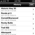
你喜歡騎腳踏車,遠足,滑雪或進行任何活動嗎?你有沒有想過到底有多少你正在做的爬升和下降呢?如果是這樣,海拔跟蹤是給你的。 此應用程式使用iPhone的GPS接收機跟蹤海拔高度的變化,計算你的總爬升和下降,以及平均和最大梯度,平均車速,和距離,並產生海拔的個人主頁上,所有在實時。你甚至可以拖動到檔案的範圍選擇器計算統計的只是一個部分,你的路線。 該應用程式在後台工作,或鎖定您的設備,並可以與其他GPS應用程式,你可能會使用。 這個免費下載,讓您可以跟蹤一個路由的時間,復位之間的數據路由。您可以啟用“歷史記錄”選項卡保存和重新載入以前的路線與0.99美元應用程式內購買,更新路由數據從抬高資料庫的1.99美元的應用程式內購買,和電子郵件路由數據和個人資料圖片與0.99美元應用程式購買。 免責聲明:在後台運行的GPS繼續使用可能會大大降低電池的使用壽命。 Do you bike, hike, ski or perform any activity that involves lots of hills Did you ever wonder just how much climbing and descending you're doing If so, Elevation Tracker is for you. This app uses the iPhone's GPS receiver to track elevation changes, calculates your total climbing and descending as well as your average and maximum gradients, average speed, and distance, and generates an elevation profile, all in real time. You can even drag range selectors onto the profile to calculate stats for just one portion of your route. The app works in the background or with your device locked, and can run alongside other GPS apps you might be using. This free download lets you track one route at a time, resetting your data between routes. You can enable the History tab to save and reload previous routes with a $.99 in-app purchase, update route data from an elevation database with a $1.99 in-app purchase, and email route data and profile images with a $.99 in-app purchase. Disclaimer: Continued use of GPS running in the background can dramatically decrease battery life.

